Like Earth, Mars has concentrations of water ice at both poles. Because Mars is so much colder however, carbon dioxide ice is deposited at high latitudes in the winter and is removed in the spring, analogous to winter-time water ice/snow on Earth.
Around the south pole there are areas of this carbon dioxide ice that do not disappear every spring, but rather survive winter after winter; this persistent carbon dioxide ice is called the south pole residual cap. The retention of carbon dioxide ice throughout the year by the southern polar cap is one characteristic that distinguishes it significantly from Mars’ north polar cap.
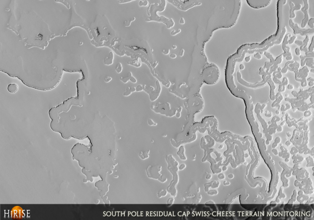
As can be seen in this HiRISE image of the south pole residual cap, relatively high-standing smooth material is broken up by circular, oval, and blob-shaped depressions. This patterned terrain is called “swiss cheese” terrain. The high-standing areas are carbon dioxide ice with thicknesses of several to approximately 10 meters. The depressions are thought to be caused by the removal of this carbon dioxide ice by sublimation (the change of a material from solid directly to gas). As most depressions seem to have relatively flat floors, there is likely some layer below, possibly made of water ice, that cannot be as easily removed by sublimation. Complicated shapes arise when neighboring growing depressions intersect.
A previous Mars imaging system, the Mars Orbiter Camera (MOC), took images of the same places on the south pole residual cap every year for many years, and showed that there are annual changes taking place within it. By looking at different sizes and shapes of depressions in an image such as this, and by comparing images of the same place from year to year, the development of “swiss cheese” terrain can be described. The sublimation process may begin as a small, shallow depression in a smooth surface. This depression then deepens until reaching the resistant layer below, and continues to expand laterally in all directions, creating the generally round depressions we see today. Different heights and thicknesses of smooth areas, and different depths of depressions, may indicate that multiple episodes of accumulation and sublimation have occurred.
This is one of the locations previously monitored at lower resolution by MOC. With the high resolution and repeat-imaging capability of HiRISE, we intend to continue monitoring and better measure the amount of expansion of the depressions over one or more Mars years. This is one of the locations specifically targeted by HiRISE for this purpose.
Knowing the amount and rate of carbon dioxide removal can give us a better idea of the role of carbon dioxide (the main component of the Martian atmosphere) in polar and atmospheric processes, of current environmental and climatic conditions, and of how Mars climate may be changing.
In HiRISE images such as this one, it is evident on the slopes of the large, especially high mesa just above the center of the image that the carbon dioxide-rich material may be constructed of several individual horizontal layers. However, it also appears that as erosion eats into the mesa, pieces of a stronger mesa surface layer break off and are left strewn on the mesa slopes, where they may give the appearance of layering.
An interesting feature in this HiRISE image is the crisscrossing network of faint ridges and troughs on the upper smooth terrain. These may also be complexly involved in the sublimation and deposition of carbon dioxide ice.Written by: Patrick Russell (19 September 2007)
More info and image formats at http://hirise.lpl.arizona.edu/PSP_004765_0940
Image: NASA/JPL/University of Arizona